


Aqua Map Boating
3.4120.00 Reviews
App Specs
- Version
- 45.3
- Updated On
- License
- Free
- Downloads
- 100,000+
- Developer
- GEC S.R.L.
- Categories
- Maps & Navigation
- Platform
- Android
Screenshots
 Analysis by AppCompare
I judge a boating chart app by what it helps me do before leaving the dock and how useful it remains once the phone loses signal. Aqua Map Boating is aimed at that practical side of navigation: it brings chart information and marine-focused tools together for planning and time on the water. I find it most appealing to people who want more than a general-purpose map, though it takes some preparation and attention to use well.
Who will get the most from it
This is a maps and navigation app from GEC S.R.L., and the focus is clearly boating rather than road directions or casual trip discovery. If you regularly plan coastal outings, check chart information, or want an anchor alarm available on your phone, its set of tools is more relevant than a standard mapping app. It is also free to install, which makes it reasonable to explore before deciding whether its paid options suit your needs.
It is less compelling if you only want a simple way to get from one marina to another, or if you expect a phone app to make every navigation decision for you. I treat charting software as a planning and situational-awareness aid, not a substitute for seamanship, a suitable primary navigation setup, or checking conditions before departure.
A routine that makes the charts more useful
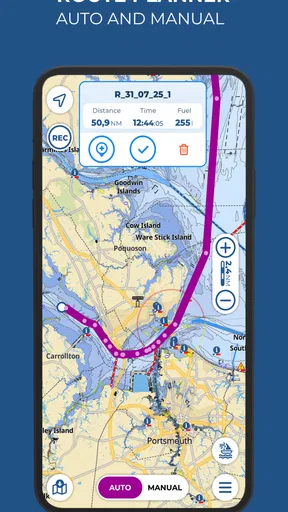
My preferred workflow starts on shore, where I can look at the chart without the distraction of handling the boat. I would check the intended area, sketch the route using waypoints, and review the route as a whole rather than assuming an automatically suggested line is appropriate. A plotted path is a starting point: local knowledge, vessel draft, weather, visibility, and changing conditions still matter.
Before setting off, I would also make sure the charts and route I expect to need are available offline. That small habit is especially valuable when a trip may take me beyond reliable mobile coverage. Offline access helps with continuity, but it does not make chart information infallible or remove the need to keep an eye on the surroundings.
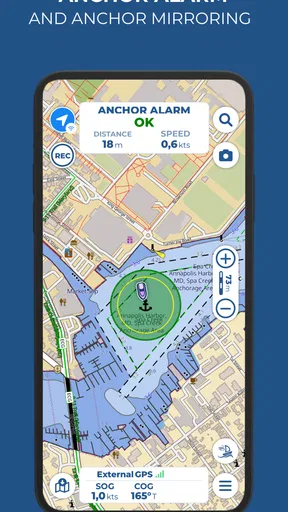
The app’s anchor alarm fits naturally into a separate routine after choosing an anchorage. I would set it deliberately once the boat is settled, then check that the phone is positioned and configured in a way that lets me notice an alert. An alarm can add reassurance overnight, but it works best as one layer of awareness rather than a promise that every movement or problem will be caught.
Settings and habits worth checking
One practical tip is to avoid leaving all preparation until the last minute. Downloading the relevant chart area and checking the planned route while connected gives me time to spot missing coverage or an awkward waypoint before departure. I would also get familiar with the chart controls at home; tapping around for the first time while underway is an easy way to make a manageable task feel stressful.
Worth Reading Before You Choose

EA SPORTS FC Mobile 26 Is a Bigger Football Game, but It Takes Time

Flipboard Shows What News Apps Must Do Beyond the Feed

Switching to Android Auto Means Rethinking Your Driving Routine

Google Calendar Makes a Crowded Week Easier to Manage

Ludo King Makes the Most of the Minutes Between Plans

Baby Panda World Brings Quick Play to Modern Phones, but Its Game Library Feels Busy
For a repeat route, I would keep a consistent pre-departure checklist: confirm the chart area, inspect the route, review current marine conditions, and decide whether the anchor alarm is needed at the destination. NOAA charts, Army Corps of Engineers surveys, and marine forecasts give the app a broader role than a basic location display, but those resources answer different questions and should not be treated as interchangeable.
Where it fits among boating apps
Compared with a general navigation app, Aqua Map is more specifically shaped around marine charts and boating tasks. A general map may be quicker for finding a place on land or arranging a drive to the launch point; it is not the same thing as checking nautical information. On the other hand, boaters who already rely on another chartplotter or a familiar navigation service may not want to move their whole routine into a phone app. I see Aqua Map as useful when its chart and planning tools complement the equipment and knowledge already aboard.
There is also a learning curve. The app’s range can be a strength for an experienced user who wants to consult several kinds of marine information, yet a first-time boater may need patience to understand what each view contributes. Its average rating is 3.5 from around 900 ratings, so I would approach it with realistic expectations rather than assuming every user will find the interface effortless. It has more than 100,000 installs and is rated for everyone; the current version is 43.1, and it runs on Android 8.0 or later.
Cost deserves a quick check before building a routine around it. The app is free, but it offers in-app purchases ranging from $2.99 to $139.99 per item. I would first decide which charts or functions matter for the waters I actually use, then review the available purchase details in the app rather than assuming every capability is included at no cost. That is a sensible step for occasional users as well as regular cruisers.
Setting Sail with Aqua Map Boating
First things first, getting started with Aqua Map Boating is a breeze. After downloading the app, available on both Android and iOS, I was up and running in no time. The user interface is intuitive, which is great because the last thing you want to do is fiddle with settings when you’re trying to focus on navigating.
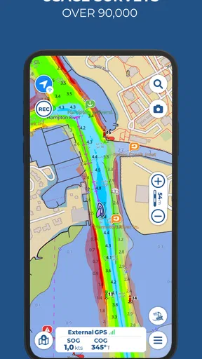
One of the standout features I noticed immediately was the detailed nautical charts. These charts are top-notch, offering a wealth of information that made me feel like I had a seasoned navigator by my side. The app includes NOAA charts for the US, which are updated regularly, ensuring you have the most current information at your disposal.
Features That Float My Boat
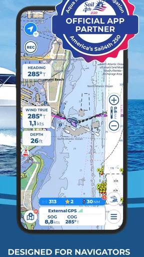
The route planning feature is where this app truly shines. With Aqua Map Boating, planning a trip is as simple as dropping waypoints and letting the app calculate the best route. The app also integrates with ActiveCaptain, so you can tap into community-sourced insights about marinas, anchorages, and hazards.
I also appreciated the offline functionality. Being out at sea often means spotty internet connections, but Aqua Map Boating lets you download charts and routes ahead of time. This means peace of mind, knowing you won’t be left adrift if your signal drops.
Another feature worth mentioning is the anchor alarm. I’ve had nights where I slept better knowing that if my boat started drifting unexpectedly, I’d be alerted right away. This kind of practical safety feature is invaluable.
Smooth Sailing or Rough Waters?
While Aqua Map Boating offers a lot of great features, there are a few areas that could use some fine-tuning. The app can be a bit resource-heavy, occasionally slowing down my phone, especially when using multiple features simultaneously. However, this is a minor inconvenience compared to the benefits it offers.
Also, while the app is quite comprehensive, beginners might feel slightly overwhelmed at first. A more detailed tutorial or help section could go a long way in easing new users into the app’s full potential.
Final Thoughts
Overall, Aqua Map Boating is a powerful tool that every boater should consider adding to their arsenal. Its combination of detailed charts, robust planning tools, and practical safety features make it an invaluable companion on the water. Sure, it has a few quirks, but what app doesn't?
Whether you’re charting a course for a weekend adventure or just want to ensure you have the best information available at your fingertips, Aqua Map Boating has got you covered. So go ahead, download it, and set sail with confidence. Trust me, you won’t want to leave the dock without it!
Making a short outing less hurried
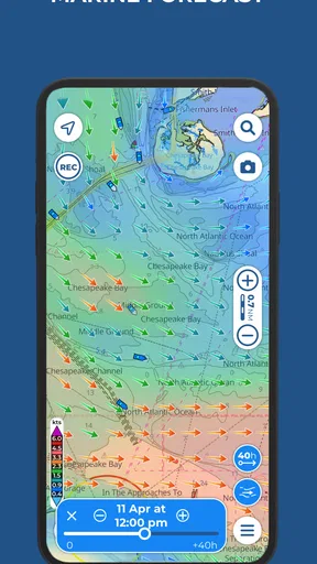
For a realistic weekend plan, I would use the app the evening before rather than waiting until the boat is ready to leave. I can check the chart around the launch area, mark a few intended points, and save the route while I have a steady connection. The next morning, the useful question is not whether the app has drawn a line, but whether that line still makes sense given the day’s marine forecast and what I know about the boat and crew.
If plans change, I would resist treating a saved route as a commitment. A waypoint is a convenient reference, not an instruction to continue regardless of conditions. Being willing to revise or abandon a plan is part of using digital navigation responsibly, especially when weather, visibility, or traffic differs from expectations.
Small workflow choices that matter underway
It helps to separate tasks that require close attention from tasks that can be handled before departure. I would do most route editing while stationary, then use the underway time mainly to consult the chart and maintain a lookout. This reduces unnecessary interaction with the screen and keeps the phone from becoming the center of attention when it should be one information source among several.
Another useful habit is to avoid downloading only the precise line of a planned trip. If a route needs to change, nearby chart coverage can make it easier to consider an alternative without relying on a connection. I would think about likely detours and the return leg too, then prepare the relevant areas before leaving. That is a planning choice, not a guarantee that every possible diversion is covered.
For an overnight stop, I would treat the anchor alarm as a check to set carefully, not a switch to turn on and forget. The boat’s position after settling, the phone’s placement, and whether I can hear or notice an alert all affect how useful the feature is in practice. If I am unsure that the alert will reach me, I would not count on it as my only safeguard.
What the app cannot decide for you
Chart detail is valuable, but it does not remove the need to interpret what is on the screen. I would not assume that an automatically calculated route accounts for every vessel-specific constraint or the latest local conditions. A route that looks neat on a display still needs a human check against the boat, the water, and the planned conditions.
Similarly, community-sourced information can add helpful context about places and hazards, but I would weigh it alongside charts and current conditions rather than treating every comment as authoritative. The distinction matters: a report can be useful for deciding what to investigate, while the final navigation decision remains mine.
The app’s US chart resources make it a natural fit for boaters working with NOAA coverage and related marine information. If my trips were centered elsewhere, I would first verify that the chart coverage I need is available and appropriate before paying for anything or depending on the app. That check is more useful than assuming a strong feature set automatically means equal usefulness in every region.
Choosing it for the right job
I would recommend trying it if you want boating-specific charting, waypoint-based planning, offline preparation, and an anchor alarm in one mobile app. It is particularly appealing to someone who enjoys preparing a route and checking several kinds of marine information before heading out. The free starting point gives a curious boater room to explore, while the purchase range means it is worth deciding what coverage and tools are genuinely relevant before spending.
I would skip it as a primary choice if I wanted a very simple, turn-by-turn experience, disliked learning a chart interface, or expected one phone to replace every other safety and navigation measure. A general map is often more convenient for reaching a launch site by car, and dedicated onboard equipment may suit someone who wants a permanent navigation display. Aqua Map sits between those uses: more marine-focused than an everyday map, but still best treated as one part of a responsible boating setup.
My considered verdict
My strongest advice is to make the app part of a repeatable routine instead of opening it only when a question arises on the water. Prepare charts and routes in advance, inspect the planned line with a critical eye, and decide how you will use the alarm before anchoring. Those habits make its practical strengths easier to benefit from and reduce the temptation to trust a screen without context.
GEC S.R.L.’s app has a clear place for boaters who want marine charts and planning tools close at hand, but it is not a universal answer for every trip or every user. I like the combination of chart-based preparation, offline use, community context, and an anchor alarm; I also think the learning curve, phone performance, and need to assess paid options deserve honest consideration. Used thoughtfully, it can be a useful companion. Used as a substitute for judgment or preparation, it is the wrong kind of reassurance.
Pros
- User-friendly interface for easy navigation.
- Detailed maps with offline access.
- Real-time weather updates available.
- Customizable waypoints and routes.
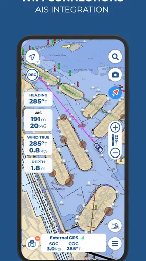
- Integration with AIS networks.
Cons
- Limited free features
- subscription needed.
- Occasional lag with older devices.
- Battery consumption is relatively high.
- Some features require internet connection.
- Interface might feel cluttered to new users.
FAQs for Aqua Map Boating
What features does Aqua Map Boating offer for navigation?
Aqua Map Boating provides a comprehensive suite of navigation tools designed for boaters. The app includes detailed marine charts, route planning, and real-time GPS tracking. It also features anchor alarms, AIS support, and advanced weather forecasts to ensure safe and efficient boating experiences. Users can access offline maps, making navigation possible even without internet connectivity.
Is Aqua Map Boating available offline?
Yes, Aqua Map Boating allows users to download charts for offline use. This feature is particularly useful when navigating areas with limited or no internet access. Users can pre-download the necessary maps for their routes, ensuring that they have access to all essential navigation information regardless of connectivity.
How user-friendly is Aqua Map Boating for beginners?
Aqua Map Boating is designed with an intuitive interface that makes it accessible for both beginners and experienced boaters. The app offers a clean layout with easy-to-understand icons and menus. Additionally, it provides tutorials and support to help new users get acquainted with its features quickly and efficiently.
What devices are compatible with Aqua Map Boating?
Aqua Map Boating is compatible with both Android and iOS devices. It runs smoothly on smartphones and tablets, providing flexibility for users to choose their preferred device for navigation. The app is regularly updated to ensure compatibility with the latest operating systems and device models.
Does Aqua Map Boating include weather updates?
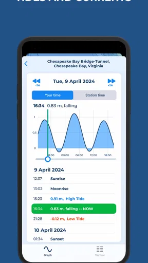
Yes, Aqua Map Boating provides up-to-date weather information as part of its features. The app offers detailed weather forecasts, including wind speeds, wave heights, and tide information. This allows users to plan their trips more effectively and make informed decisions based on current and predicted weather conditions.


